When we talk about traffic, curbs aren’t the first thing that come to mind, but they play a big role in how city streets function. Delivery vehicle drop-offs are crucial, and the logistics of parking in busy areas can be more than tricky.
Seattle has 500 loading zones for package, food and supply deliveries, but what happens when a truck pulls up and every zone is full? The drivers may end up blocking a lane, increasing congestion and air pollution, and they may be delayed as well. In short, curbs are a battlefield.
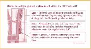
With the Open Mobility Foundation, Seattle’s Department of Transportation is creating a way to digitally define loading zones and measure their effectiveness through a Curb Data Specification (CDS). The goal is to have a publicly available digital representation of the loading zones and a digital feed that guides curb users to where, when and how long they can park as they make deliveries. The specification can match delivery vehicles with curb spaces and provide them with the best route to get there.
The city and researchers can also use the real-time open source data about loading space usage to design better curb management. For instance, the city can increase curb regulations to preserve needed space and identify underused zones.

A visual example of how CDS defines curb zones. Image credit: Open Mobility Foundation.
The department plans to work with partners to pilot a digital permit program for commercial vehicles to reduce congestion, expand curb access and promote sustainability in delivery across the city.
This article appeared in our guide, “State and Local: Making an Impact.” For more insights on how state and local governments are using digital transformation to enhance life in their communities, download it here:


0 Commentaires